

What do the rumblings of Iceland’s volcanoes have in common with the now peaceful volcanic islands off Scotland’s western coast and the spectacular basalt columns of the Giant’s Causeway in Northern Ireland?
Iceland sits over a mantle plume — a fountain of hot rock that rises from Earth’s core-mantle boundary — explaining, in part, why this is one of the most volcanically active places on Earth.
But around sixty million years ago, at a time when the North Atlantic had not yet opened, the Iceland plume was unleashing volcanic activity over a much wider area. The volcanic monoliths of western Scotland and Ireland are part of a network of volcanoes and lava flows that spread over thousands of kilometres, reaching as far west as Greenland.
The Iceland Plume is the largest mantle plume on Earth and its influence at the surface even extends to shaping ocean circulation in the North Atlantic, and in turn climate, through time. Despite the plume’s global importance, its workings remain elusive.
Seismologists and petrologists from Cambridge Earth Sciences came together at this year’s European Geosciences Union General Assembly to present their efforts to unlock the mysteries of the plume; from the ‘seismic CT scans’ that allow them to look deep into its plumbing system, to the mission to drill into the ocean floor and retrieve rocks that tell of the plume’s dynamic history.
Scattered volcanic remains
“Scientists have a lot of unanswered questions about the Iceland plume,” said Raffaele Bonadio, a postdoc working with Sergei Lebedev at Cambridge’s Department of Earth Sciences. One aspect of the Iceland plume that intrigues Bonadio is why it triggered such widespread volcanic activity early in its infancy.
Answering that question requires Bonadio to home in on a smaller segment of the so-called North Atlantic Igneous Province and understand the complex distribution of volcanoes in Scotland and Ireland first.
Bonadio has been using seismic data extracted from earthquakes to create a computer-generated image of the Earth’s interior beneath Britain and Ireland. This method, known as seismic tomography, works in a similar way to a medical CT scan, to reveal hidden structures in Earth’s interior.
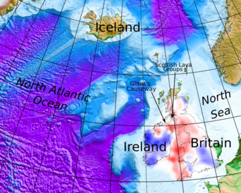
Relief map of the Britain and Ireland and the surrounding North Atlantic Ocean. Areas of thicker, strong lithosphere (blue) and thin, weak lithosphere (red) in Britain and Ireland are shown. Data and illustration credit: Raffaele Bonadio.
He has found that northwest Scotland and Ireland’s volcanoes formed in areas where the lithosphere (Earth’s rigid outer layer) is thinner and weaker. Bonadio presented his research at the EGU’s April meeting in Vienna.
“We see ancient volcanic outcrops concentrated within this corridor of thin lithosphere beneath the Irish Sea and surrounding areas,” said Bonadio. He thinks magma was preferentially funnelled along this corridor, because it could rise more easily through the thinner lithosphere.
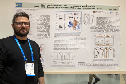
Raffaele Bonadio with his poster at EGU.
The widespread distribution of ancient volcanoes and lava outpourings across the North Atlantic, stretching over thousands of kilometres, has led some scientists to put forward alternative, non-mantle plume origins for the volcanic activity, said Bonadio. But his new research shows the scattering could be explained by the magma being diverted and re-routed to areas of thinner lithosphere.
Previously, similar investigations led by Cambridge’s Sergei Lebedev showed that the presence of thinner, more fragile lithosphere beneath the Irish Sea and western Britain could explain why this area experiences more earthquakes than Ireland or eastern Britain, solving a longstanding mystery as to why Britain and Ireland experience variable seismic activity.
Magma takes the easy route
Cambridge Earth Science’s Janneke de Laat is interested in how the Iceland plume works today, in its current configuration beneath Iceland. De Laat, who is also working with Lebedev, has been using a similar seismic imaging method to track the plume’s wandering journey as it rises toward the surface from hundreds of kilometres down.
She is using seismic data that was produced by the Dublin Institute for Advanced Studies’ SEA-SEIS project, which deployed 18 ocean-bottom seismometers on the North Atlantic seafloor in 2018.
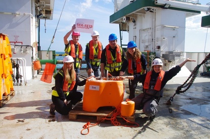
The SEA-SEIS Expedition team with one of their ocean bottom seismometers. Janneke de Laat is second from the right, Sergei Lebedev second from the left.
“Most seismic stations are based on land,” said De Laat. “We wanted more coverage in the North Atlantic Ocean, to fill that gap in data.” By combining the new seismic data with a global database of seismic waveforms, De Laat is now able to create a clearer image of the Iceland plume’s deviating route to the surface.
Her new model shows that, at depths of about 400 kilometres, the Iceland plume is angled toward Greenland, but, as it rises toward the surface, it changes course toward Iceland.
That dogleg is probably because Greenland has a thick and impenetrable root, said De Laat, “the plume is bumping up against Greenland, so instead takes the easier route towards the Mid Atlantic Ridge.” Once near the surface, the flow is channelled southwards away from Iceland, along a section of the Mid Ocean Ridge known as the Reykjanes Ridge, she said.
Some scientists have previously suggested that the current plume head might radiate outwards at the surface and even still have branches that extend toward the UK, said De Laat, “but that’s not what we see — the flow is concentrated to the south of Iceland.”
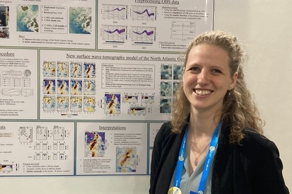
De Laat presented her poster at EGU.
Rocks tell the plume’s history
Study a bathymetric map of the Reykjanes Ridge and you might spot a series of V-shaped patterns on the ridge flanks. “These troughs and ridges are one of the clearest manifestations of the Iceland plume’s interaction with the Mid Ocean Ridge,” said PhD student Callum Pearman, whose research explores what these features reveal about the plume’s changing behaviour through time.
“These chevron features have confused scientists for decades, and the debate on their origin remains fierce,” said Pearman, who is supervised by Cambridge Earth Science’s Nicky White and John Maclennan.
One popular view is that they were etched into the seafloor because of temperature fluctuations inside the Iceland plume. With each thermal pulse, the seafloor above the plume swelled and contracted; movements that may, in turn, have shifted deep water currents in the North Atlantic and even had knock-on effects on our climate.
In search of answers, the International Ocean Discovery Program (IODP) have drilled through 500 metres of basaltic rock on the flanks of the Reykjanes Ridge. Nicky White was one of thirty scientists on board the 2021 IODP mission, and he led the original seismic survey which helped locate the drilling sites. Pearman has been analysing the chemical profile of these rocks to gauge how the internal temperature of the Icelandic plume has fluctuated through time.
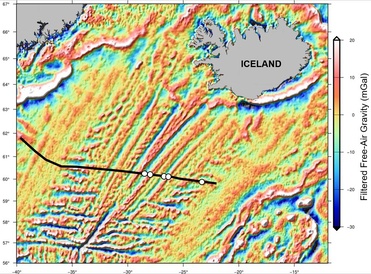
Gravity map of Iceland and the Mid Ocean Ridge stretching away to the southwest. The chevron features are radiating at oblique angle out from the Mid Ocean Ridge. The transect of holes drilled by the International Ocean Discovery Program are indicated. Image credit: Callum Pearman.
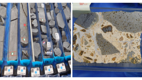
Drill cores of basalt rock retrieved by the IODP. On the right is a sample of peperite, an unusual rock that forms when hot basaltic lava comes into contact with wet sediments. Image credit: Nicky White.
Presenting his research at EGU, Pearman said that he has already uncovered intriguing compositional differences between V-Shaped ridges and troughs, which he can link to long and short-term variations in mantle temperature. He and the wider IODP team are continuing their geochemical investigations to piece together the plume’s history.
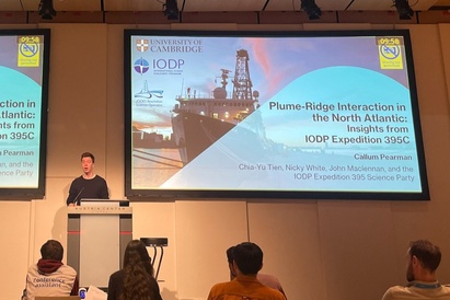
Pearman presented his research at EGU.
For Pearman, one of the attractions of studying the enigmatic Iceland plume is its far-reaching influence: going beyond the volcanism in Iceland to the role it has played in palaeoceanography and even shaping our climate through time.
Solving wide-ranging questions like this, which are fundamental to how our planet works, is uniting geoscientists with varied backgrounds from across Cambridge and beyond.
Further reading
Bonadio, R., Lebedev, S., Chew, D., Xu, Y., and Fullea, J.: How could a single Iceland Plume produce the widely scattered North Atlantic Igneous Province volcanism? New clues from Britain and Ireland., EGU General Assembly 2024, Vienna, Austria, 14–19 Apr 2024, EGU24-18296, https://doi.org/10.5194/egusphere-egu24-18296, 2024.
De Laat, J. I., Lebedev, S., Bonadio, R., Thsekhmistrenko, M., and Celli, N. L. and the SEA-SEIS Team: Waveform tomography of the upper mantle beneath the North Atlantic region using regional seafloor and global data., EGU General Assembly 2024, Vienna, Austria, 14–19 Apr 2024, EGU24-11074, https://doi.org/10.5194/egusphere-egu24-11074, 2024.
Pearman, C., White, N., Maclennan, J., and Tien, C.-Y. and the IODP Expedition 395 science party: Temporal Record of Plume-Ridge Interaction in the North Atlantic: Interdisciplinary Insights from IODP Expedition 395C, EGU General Assembly 2024, Vienna, Austria, 14–19 Apr 2024, EGU24-557, https://doi.org/10.5194/egusphere-egu24-557, 2024.
Feature image: Earth from Space: Iceland. Credit ESA. CC BY-SA 3.0 IGO.