

In the southwestern Atlantic Ocean, off the coast of Brazil, warm tropical waters flow southward and meet colder currents travelling north from the sub-Antarctic region. At this point, two significant water masses of contrasting temperature and salinity converge: forming a swirling, turbulent zone known as the Brazil-Malvinas Confluence.
PhD student Xiaoqing Chen, who is supervised by Professor Nicky White, has been using seismic imaging — a technique which works like medical CT scanning — to see deep into the interior of this energetic patch of ocean and document its inner-workings in new detail.
Chen’s seismic images provide a cutaway view through the Brazil-Malvinas Confluence — illuminating previously unknown internal structures. The new view has yielded staggering finds, including a 40-kilometre-wide vortex hidden deep inside the Confluence and located between 500 metres and 1000 metres below the ocean surface.
“The eddy looks like a huge pancake,” said Chen, “no one has ever seen this feature before, it’s a really exciting find.” Chen added that the mechanisms driving the eddy are currently a mystery, but her observations show that it swells and shrinks on a cycle that repeats roughly every eleven days.
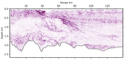
Seismic section through the Brazil-Malvinas Confluence. Credit: Xiaoqing Chen.
Even massive features like this have previously been missed by traditional oceanographic surveys, which are limited in their horizontal resolution and produce more grainy images, said Chen.
Typically, ocean observations are measured using buoys towed behind boats or, in recent decades, are based on satellite imaging of surface water properties such as temperature and salinity. “It’s very unusual to find these structures because of the limitations of other measurements,” said Chen. “Seismic imaging is a really powerful tool.”
Seismic imaging has only been used by oceanographers a handful of times, but the technique is familiar to many geologists who use it to see layers beneath Earth’s solid sub-surface. Geophysicists often survey the seabed using seismic imaging, explained Chen, but tend to slice off the unwanted images of the ocean above.
“There is still plenty of archived and unexplored seismic data from the oceans,” said Chen, “and that means lots of opportunities to identify more features hidden in those datasets.”
Chen is also using her data to quantify how much mixing is happening inside the eddies, which will help understand their role in transferring heat and carbon dioxide around the ocean and to the atmosphere.
Last year, Chen presented these findings at the European Geosciences Union General Assembly. She recently received an award from the EGU for her poster presentation, ‘Time-Lapse Volumetric Seismic Imaging of Water Masses at a Major Oceanic Confluence in the South Atlantic Ocean.’
Feature image: Satellite image of the Brazil-Malvinas Confluence, taken in 2019. Photo credit: NASA Earth Observatory.