

Some of the most dramatic landforms on Earth — from majestic fold mountains to deep ocean trenches — are created at plate boundaries. But sometimes topographic features cannot be explained by plate tectonics alone.
Cambridge Earth Sciences’ Philippa Slay, PhD student with Nicky White, is investigating evidence for topographic anomalies — called ‘dynamic topography’ — in the Australian continent. Slay recently received an award from the European Geosciences Union for her poster presentation, ‘Observed Dynamic Topography and Cenozoic Magmatism of the Eastern Seaboard of Australia,’ at the 2023 General Assembly.
“Australia is far away from plate boundaries, and yet its topography is incredibly varied,” said Slay. A chain of mountains sweeps the length of Australia’s eastern seaboard and broad topographic highs extend over much of western Australia. “Australia is an ideal place to study how dynamic topography forms, due to its passive margins.”
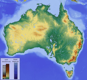
Relief map of Australia, showing some of the topographic highs that are not associated with active plate boundaries. Credit: Wikipedia Commons.
Dynamic topography is the surface expression of convection currents churning deep within Earth’s solid mantle. Where warm, lower density mantle rises up towards the surface it pushes the rigid, overlying lithosphere upwards — creating upstanding features reaching thousands of kilometres across. Conversely, where cold and dense mantle sinks, the overlying lithosphere sags downward — creating a wide topographic basin at the surface.
Dynamic topography can’t be measured directly, so scientists instead compare on-land topography and offshore bathymetry with the elevation they’d expect to see. By comparing the real topography with the expected, they can isolate the influence of dynamic topography.
That deviation from expected elevation is easier to measure offshore because ocean plates cool and sink systematically as they age — meaning that scientists can better estimate how deep the seabed should be without the influence of dynamic topography. The relationship is more complex onshore, and so scientists use a compilation of global crustal measurements to get a sense of the expected elevation to which they can then compare the actual elevation.
Using this approach, Slay found that dynamic topography was particularly prevalent in the western third of Australia. “That makes sense, and it ties in with existing evidence from the geological record, like uplifted valleys,” said Slay.
Beyond dynamic topographic measurements, there are a number of other data sets which can be used to infer mantle support. Slay explained, “we’re not just relying on our own measurements, for example, along the eastern seaboard there are many observations pointing towards positive dynamic topography”. Factors like hotspot volcanic activity and a positive gravity anomaly suggest to Slay that there might be buoyant mantle supporting the elevated topography in eastern Australia.
Slay said that attending EGU helped her develop the research, “I had so many interesting conversations about my poster at EGU, I’ve taken that feedback and built it into ongoing investigations.”
Slay also presented the results of her investigations at the 2023 AGU Annual Fall Meeting.