Submitted by Dr C.M. Martin-Jones on Thu, 14/12/2023 - 11:39
You might think Earth’s deep and rocky interior is relatively featureless but, three thousand kilometres beneath our feet, enigmatic structures akin to colossal mountain ranges rise from the edge of the planet’s core.
“It’s anything but boring down there,” said Carl Martin, who has just completed his PhD in the Department of Earth Sciences, “these features are just fascinating.”
Martin used seismic waves generated by earthquakes to create the first global map of the structures, which are located at the boundary between Earth’s liquid iron outer core and the surrounding rocky mantle. He will present the results at this year’s AGU Annual Fall meeting.
To build his map, Martin compiled thirty years of data from large earthquakes picked up by seismic stations across the world. He simulated each quake — tracing the path of the seismic waves as they diffracted around the core-mantle boundary and were refracted by structures called ultra-low velocity zones, or ULVZs.
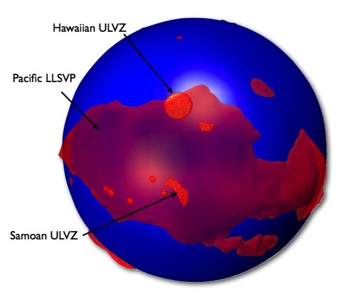
These ULVZs are hundreds of kilometres across (so roughly country-sized) and are thought to be made of dense iron-rich material — causing seismic waves to slow dramatically when passing through them. But the exact composition of ULVZs, or their origin, is uncertain.
Previously, some ULVZs have been identified around the roots of hotspot volcanoes like Hawaii, which sit in the middle of tectonic plates — away from plate boundaries where volcanic activity usually happens.
ULVZs have also been found clustered around bigger structures called large low-shear-velocity provinces which are comparable to continents in size. Like ULVZs, large low-shear-velocity provinces have mysterious origins; some scientists think they might fuel hotspot volcanoes on the surface, but the connection isn’t clear.
Cartoon showing ultra low velocity zones (red blobs) and the Pacific large low shear velocity province (red transparent) on the core of the Earth (blue). Credit: Sanne Cottaar.
Martin likens this collection of deep-Earth structures to a zoo of animals, “we know they have different sizes and compositions, but we can’t classify them fully yet.” For that reason, it’s difficult to say how ULVZs, low-shear-velocity provinces and hotspots are linked, he explained, “we hope, with more observations, to understand them more fully.”
Previous studies have mapped ULVZs in areas of interest by analyzing earthquakes that sample discrete regions of the core-mantle boundary. Martin’s dataset instead gives a global view, “that meant we found many new structures we didn’t know existed before,” said Martin. He found that some of the newly-identified ULVZs occur where there isn’t any surface expression of hotspots, “that leaves us with more questions, and probably requires additional, detailed classification to distinguish why some ULVZs are related to hotspots.”
Martin said his new observations might be limited to some degree by the distribution of earthquakes in the global catalogue, and the fact that large seismic arrays are more frequently located in the northern hemisphere. He also noted that they were less successful in picking out the smallest ULVZs, which some studies had identified by looking for different seismic wave frequencies.
“What we’re starting to get is a global picture of the structures on the core-mantle boundary," said Martin, "that’s a really important step in trying to unravel how they are geodynamically linked."
Feature image: Hawaiian lava flow. Credit: {sara-ann} on Flickr. CC BY-SA 2.0.

