Earthquakes and Volcanoes
Earthquakes and volcanic eruptions are incredible and dramatic natural events. On this page you can learn more about the science behind them:
- Bárðarbunga-Holuhraun Eruption
Learn about the 2014 Bárðarbunga eruption and the massive Holuhraun lava field that it created. - Fascinating Facts
Discover interesting facts that you might not know about earthquakes and volcanoes.
Bárðarbunga-Holuhraun Eruption
Iceland sits on crack in the surface of the Earth where two tectonic plates (large blocks that make up the outer most layer of the Earth) are ripping apart from each other. These two blocks are moving apart at around 2 cm per year (approximately the rate that your finger nails grow) and are slowly widening the Atlantic Ocean; increasing the distance from Europe to North America. As the tectonic plates split apart magma (molten rock) wells up from below forming volcanoes, which creates new land in between. This rifting process is happening all the way down the middle of the Atlantic Ocean beneath the sea. But at Iceland we see the process on land because a hot upwelling from deep within the Earth also sits beneath Iceland, pushing it upwards out of the sea and making the area even more volcanically active.
Iceland has over 30 active volcanic systems, which have a central volcano in the middle with long cracks spreading outwards to the north and south (fissure swarms). Magma (molten rock) can erupt from the central volcano itself, or travel through the cracks of the fissure swarm to create long lines of eruptions far from the volcano itself.
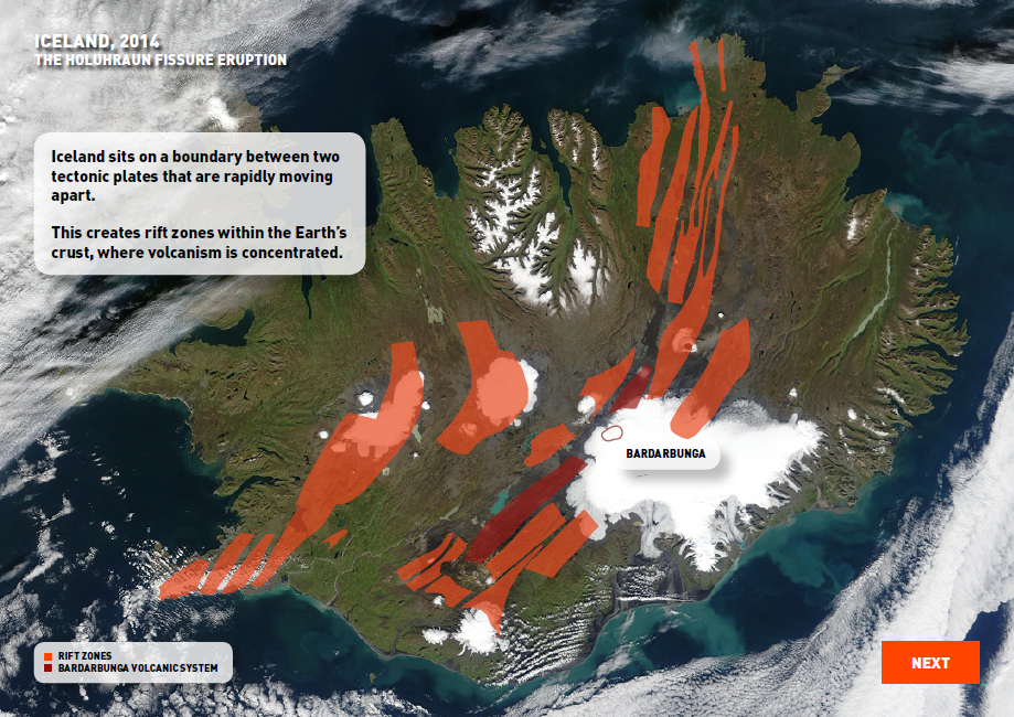
The main volcanic rift zones in Iceland, with Bárðarbunga volcano beneath the Vatnajökull ice sheet.
When you think of Icelandic volcanoes, the one you will probably remember is the eruption of the volcano with the long, hard to pronounce name that had news readers getting their tongues in a twist: Eyjafjallajökull, which sits under a glacier in southern Iceland. This volcano erupted in 2010 and was all over the news because it produced so much ash that it grounded 100,000 flights and closed European air space. The main reason why this eruption was so ash heavy was due to the interaction of the hot magma erupting under the cold overlying ice. But a couple of years later in 2014 there was another eruption in Iceland, at a volcano called Bárðarbunga. It was the largest eruption in Iceland in over 200 years, and was 10 times bigger than than the eruption of Eyjafjallajökull, but it didn't ground a single flight.
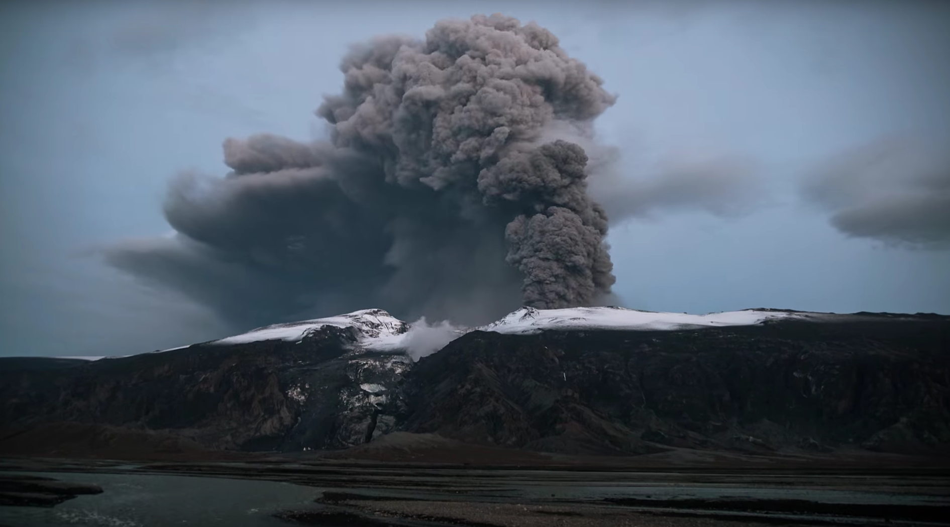
The eruption of Eyjafjallajökull in 2010 created a large ash plume that blew across western Europe.
Bárðarbunga volcano is right in the middle of Iceland in the remote and uninhabited highlands. It sits underneath the massive Vatnajökull glacier, covered by around 800 m of thick ice. Scientists first knew something interesting was happening at Bárðarbunga in August of 2014 when hundreds of tiny earthquakes were detected within the volcano deep below the ice. Teams rushed out to deploy more seismic instruments to record the earthquakes and determine where they were happening more accurately. Scientists were flown up onto the glacier in helicopters, before speeding around on snow scooters to get the essential instruments out as quickly as possible.
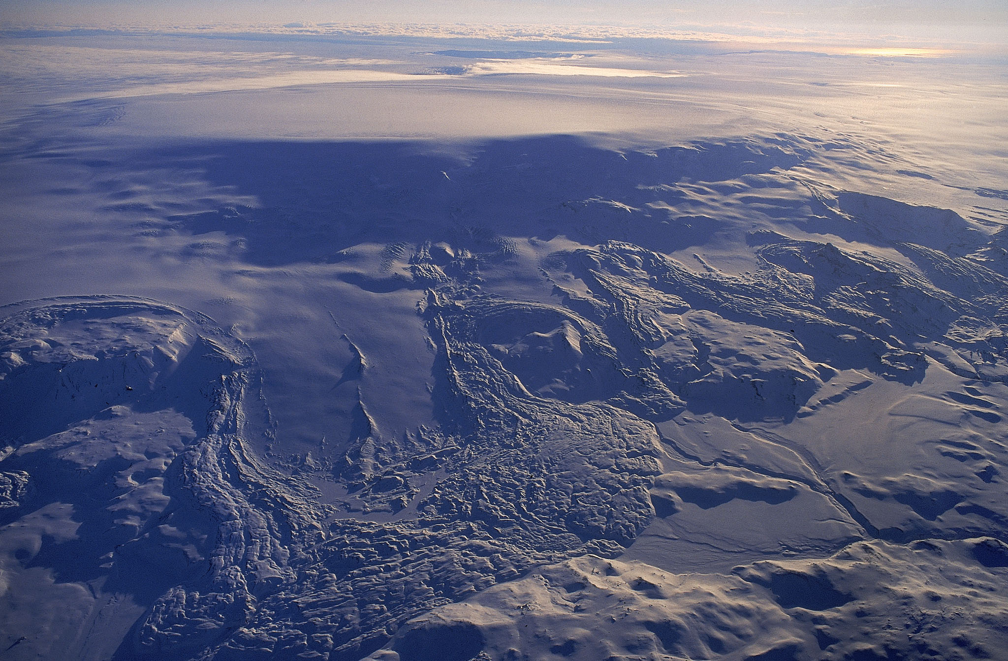
Bárðarbunga volcano beneath the Vatnajökull ice sheet.
Over the next two weeks the country watched closely as the 30,000 tiny earthquakes tracked the underground movement of the magma as it cracked a 46 km long path through the earth’s crust. The earthquake activity moved gradually northwards, away from the volcano at 6 km down within the earth, as authorities and scientists tried to guess where and when the magma would move upwards and erupt at the surface. Would the eruption happen under the glacier producing an ash heavy eruption like Eyjafjallajökull, or would it travel far enough away from the glacier that it wouldn't interact with the ice? Or maybe it wouldn't erupt at all, and the molten rock would stay deep within the earth, cooling and solidifying to form an igneous intrusion? The magma movement was also tracked using GPS and satellite measurements. The GPS were able to measure ground movement caused by the magma pushing into the earth and shoving material outwards to either side by up to 1.5 m. This helped scientists to understand the shape that the magma was flowing in—a vertical sheet of molten rock known as a dyke, about 5 m wide.
3-D visualisation of earthquake epicentres through time as the magmatic dyke propagated from the Bárðarbunga central volcano to the Holuhraun eruption site.
The dyke advanced in rapid bursts with an average speed of 2 km per hour, reaching speeds of up to 4.7 km per hour. In the end the dyke travelled 46 km away from the feeder volcano Bárðarbunga before erupting at the surface on a river flood plain away from the glacier. The eruption, which was named Holuhraun, saw runny fluid lava thrown up to 200 m into the air (higher than Big Ben!), in pulsating fire fountains, before flowing away as rivers of molten rock. There was no central eruption point, instead the eruption happened all the way down the length of a 1.5 km long eruptive fissure that over time concentrated down to a few craters, and finally to one main crater called Baugur. The amount of thermal energy the eruption produced was tremendous; equivalent to the energy of a Hiroshima sized atomic bomb being set off every 2 minutes!
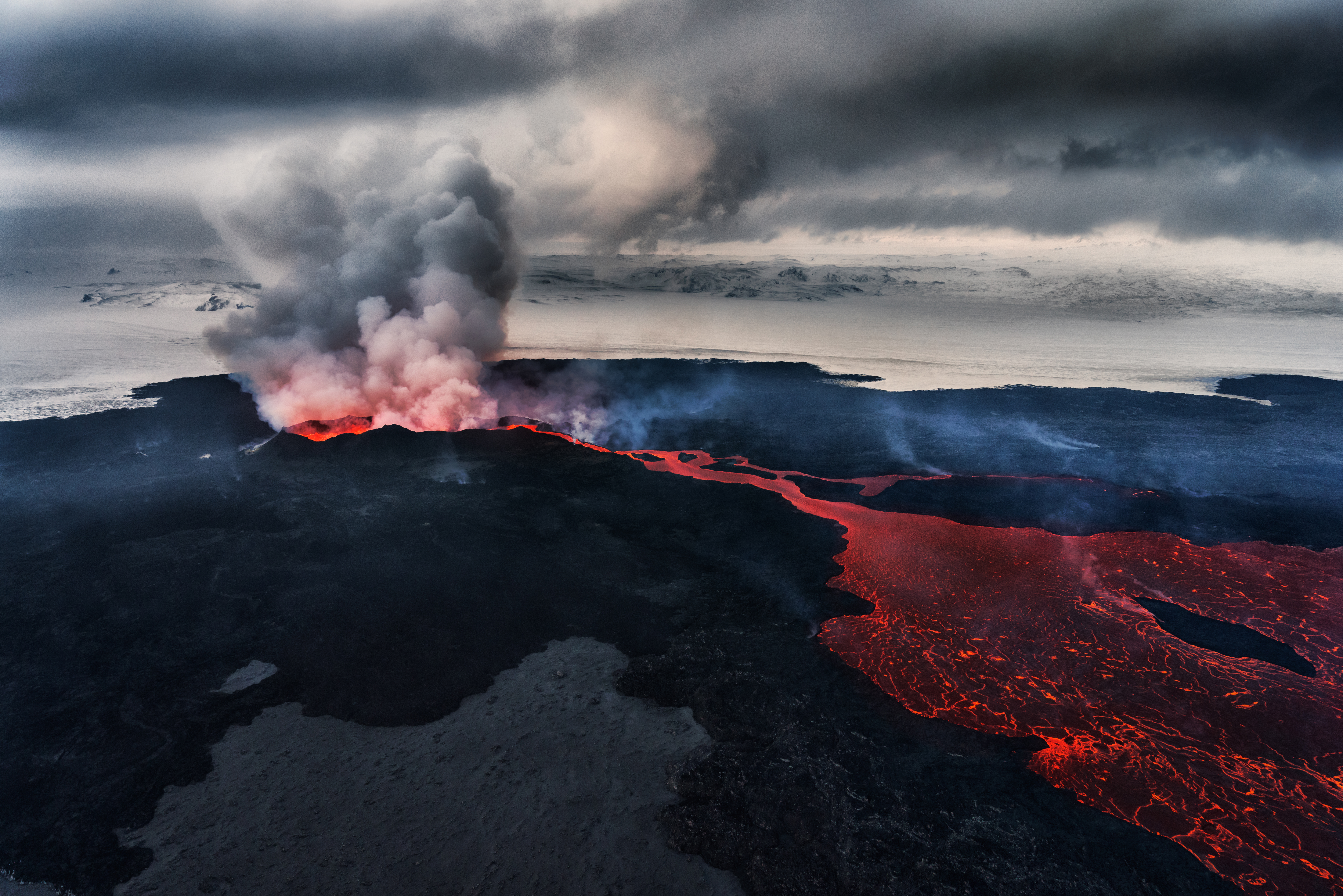
The Bárðarbunga-Holuhraun eruption in action, with a lava flow extending across the sandur and volcanic gases issuing from the volcanic vent.
Footage of the 2014 Bárðarbunga-Holuhraun eruption.
The eruption lasted for 6 months, eventually stopping in February 2015. By then it had produced 1.6 km3 of lava, covering an area of 85 km2 – large enough to cover the city of Cambridge twice (how much of your area would it have covered?). Because there was no interaction with ice, only a minute amount of ash was produced. However it did release around 11 M tones of SO2 – more than the whole of Europe produces in a year! This was the main hazard of the eruption as the gas was blown around on the wind affecting large numbers of the population. Ground level concentrations of SO2 exceeded health limits over most of Iceland for days to weeks, with the high concentrations of SO2 can cause breathing difficulties and eye irritation.
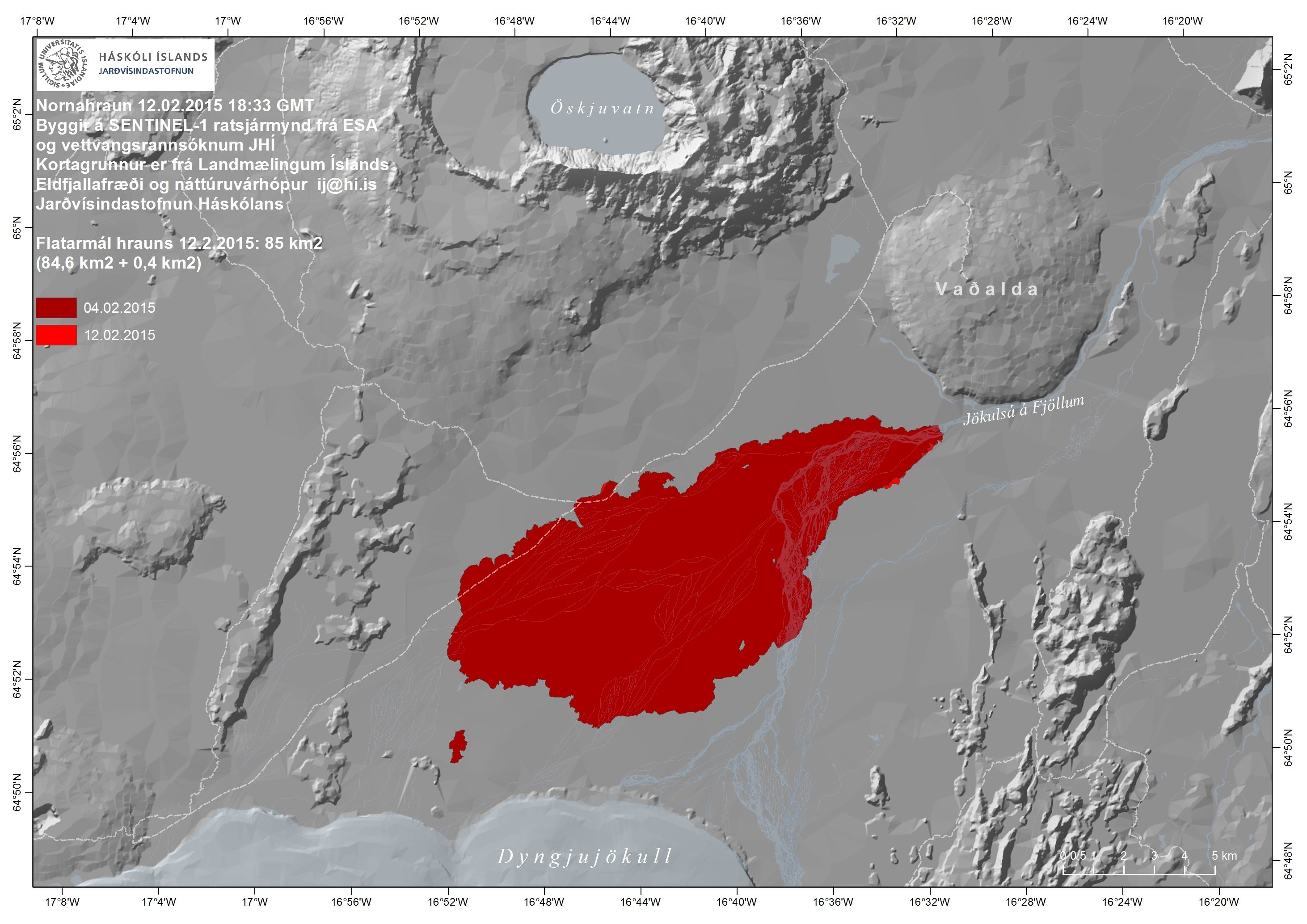
The extent of the Holuhraun lava flow in red.
It's very important to carefully monitor volcanoes to try and understand what kind of eruption they might have and what hazards that could present. The Holuhraun eruption was not hazardous to planes since it was an effusive eruption and it didn’t create a huge eruption column, but if the eruption had happened under the ice it would have been a completely different story. Measuring the tiny earthquakes that happen in volcanoes, gives us a powerful tool we can use to see inside the earth and track where molten rock is moving beneath the surface. Keeping track of these observations can help inform public bodies, aiding their decision making and their planning of hazard mitigation strategies.
Fascinating Facts
Iceland facts
- The population of Iceland is 330,000, or approximately the population of Reading.
- Two-thirds of the Icelandic population live in the capital city, Reykjavik.
- More than one million people visit Iceland each year on holiday, about three times its population.
- All of Iceland's heating and electricity is renewable, either from hydroelectric or geothermal methods.
- The UK went to war with Iceland once over fish!
- Good morning in Icelandic is ‘Góðan dag’.
- An earthquake swarm precedes eruption of the Icelandic volcano Hekla by 30 minutes, which is unhelpful if you are on the volcano, but enough time to get the news helicopters in the air from Reykjavik!
- There are about 130 volcanoes in Iceland.
Bárðarbunga-Holuhraun eruption facts
- The Holuhraun lava flow covers an area of 84 km2.
- During eruption, lava fountains sprayed lava up to 150 m high, which is taller than Big Ben!
- The eruption released vast amounts of thermal energy, equivalent to: releasing a Hiroshima atomic bomb every minute (in the first month), and every two minutes (on average over the six-month-long eruption).
- The Holuhraun lava flow released 100 million tonnes of sulphur dioxide, which is equivalent to the annual emissions of Europe.
- More than 30,000 small earthquakes were detected accompanying the magma intrusion.
- The peak rate of magma release was around 500 tonnes per second.
- Members of the Volcano Seismology Group from the University of Cambridge were the first people to see the eruption with their own eyes. They tracked the eruption in collaboration with the Icelandic Met Office and the University of Iceland during the first weeks of the eruption before they had to (reluctantly) go home.
- Instruments were placed so close to the eruption site that they had to be rescued from the advancing lava.
- The intrusion, and subsequent lava flow, was monitored in real-time by more than 100 seismometers, more than 30 GPS instruments, three satellites, and four webcams.
Eyjafjallajökull eruption facts
- The Eyjafjallajökull eruption ejected ash 35,000 feet into the air.
- The Eyjafjallajökull ash cloud grounded over 100,000 flights, which cost the aviation industry an estimated £1.1 billion.
- To volcano’s name is pronounced: "EY - A - FYAT - LA - YO - KUTL".
- The eruption caused several glacial floods (jökulhaups) when hot magma melted ice in the overlying glacier.
- Small earthquakes were detected by the Cambridge Volcano Seismology Group down to a depth of 30 km below the surface, as molten rock stored at depth migrated during the eruption.
Earthquake and seismology facts
- The magnitude scale of earthquakes is logarithmic, so every step up the scale is an earthquake ten times bigger. A magnitude 2.0 event is, therefore, ten million times smaller than the 2004 boxing day earthquake (magnitude 9.0).
- Humans have only ever dug to a depth of 12 km; less than 1% of the Earth's total thickness. The only reason we know anything about the internal structure of the Earth is because earthquake waves travel through it, and become modified by the material that they travel through.
- The United States Geological Survey (USGS) estimates that several million earthquakes occur in the Earth each year. Many go undetected because they hit remote areas or have very small magnitudes. The NEIC (National Earthquake Information Centre) now locates about 50 earthquakes each day (larger than magnitude 4.5), or around 20,000 a year.
- We get earthquakes in the UK, a few every couple of days. However, they are just very small, generally less than magnitude 2, which means that they are just too small for people to feel.
- The largest earthquake to ever happen in the UK was a magnitude 6.1 off the east coast of England in the North Sea.
- The most damaging earthquake in the UK in recent history was in 1884 near Colchester. We don’t know exactly how large it was (probably around magnitude 4.5), but historical records show that some 1200 buildings required repairs, and three to five people were killed.
Volcano facts
- There are about 1500 active volcanoes in the world.
- 300 million, or one-in-twenty, people in the world live within the 'danger range' of an active volcano.
- About 1,500 different volcanoes have erupted over the past 10,000 years, but only about 60 erupt each year. On any given day, there are about 20 volcanoes erupting somewhere in the world.
- Many volcanoes are underwater and erupt onto the sea floor.
