Frequently Asked Questions
- How do seismometers record earthquakes?
- How do you deploy seismometers in Iceland?
- Why are there so many volcanoes in Iceland?
- How do you locate earthquakes?
- Why did the 2014 Bárðarbunga eruption not ground any flights like the 2010 Eyjafjallajökull eruption which closed European airspace during the Easter holidays?
- How does ash affect planes?
- Why are some volcanic eruptions very explosive while some are not?
- Why do you sometimes get lightning during volcanic eruptions?
- Are volcanic earthquakes anything like the earthquakes caused by fracking (hydraulic fracture stimulation)?
- Why do volcanoes and earthquakes both occur in the same places, i.e., at plate tectonic boundaries?
- Where does magma come from?
- How are volcanic earthquakes different from tectonic earthquakes?
- Why don’t we get many earthquakes in the UK/will we get some?
- How many volcanoes/volcanic eruptions are there in the world?
- How many earthquakes are there in the world?
Information for Interested Adults
- What happens when magma and ice interact in an eruption?
- What are the gases that are dissolved in magma?
- What is a volcanic plug?
- What makes magma runny or viscous?
- How is volcanic ash formed?
- What types of igneous intrusions are?
- How do you make tall building earthquake-proof?
- What types of earthquake waves are there?
How do seismometers record earthquakes?
Seismometers record ground motion and earthquakes. Attached to their base is a free mass, which is usually attached by a spring/string and allowed to move freely in one direction (up/down or side to side). When the earth moves the base of the seismometer moves as well, but the free swinging mass stays still. Check out the videos below to see this principle in action. Originally a pen was attached to the mass and the base had a roll of paper to record the relative movement between the moving base and the stationary pen. Now systems tend to use magnet, which are free to move within a coil of wire, which creates an electrical current that is measured and converted into amount of ground movement.

A mass can only move freely in one direction, so seismometers record in three different directions of motion (up/down, north/south and east/west) to describe the ground motion in 3D.
Many modern devices like Macs and iPhones have small seismometers built into them, so they can detect motions and adjust the screen accordingly. This also means you can download 'seismometer' apps to have on your iPhone or Android.
How do you deploy seismometers in Iceland?
The University of Cambridge has a network of ~60 seismometers in central Iceland, visiting and servicing them every year, with a group made up of PhD students, post-docs, technicians and lecturers. We download the recorded ground motion data and carry out maintenance to ensure everything is working properly. We also often move seismometers to more useful places for the next years research plans.
Seismometers are deployed by digging a big hole and putting them in the ground, if possible onto a solid bit of rock so that they pick up vibrations and tiny movements well. They need to be completely level (which we check by looking at the spirit level on top), so sometimes the really sensitive ones are placed on top of a flat paving slab. They need to be kept dry, so are often buried in plastic barrels. They need to be pointing towards the north to make it easier for us to tell what direction seismic energy is coming from. They need to be placed in really quiet locations so they don’t record other things that could make the ground move a little, like people moving around, cars, rivers, high winds moving nearby tree roots etc. In Iceland this is really easy since all our seismometers are deployed in a barren, volcanic desert. The only thing we have to worry about is tourists/hikers walking over to see what they are and stamping around nearby, so we try and hide them out of sight of the roads!
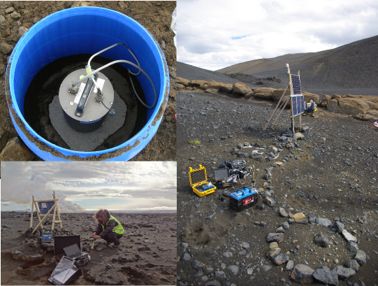
The seismometers, like most machines, need a power source to keep them going. In the remote Icelandic highlands there is no access to mains electricity, so we can’t just plug them in. Instead we use solar panels to generate electricity from the sun. Unfortunately because Iceland is so far north, for lots of the year there is very little sunlight. There is also lots of snow in the winter which can bury the solar panels. So to help the seismometer keep going when it doesn’t get any power from the solar panels, we also have several car batteries, which it can rely on until the solar panels start generating energy again.
The seismometers will record the tiny movements of the ground, sampling the motion up to 200 times per second. This information is stored within the memory of the seismometer until we come back and download it. Some seismometers stream the data live via satellite connections, but this generally requires more power than a few solar panels and batteries can provide. The Icelandic Met Office power several of our instruments and use them for real-time monitoring.
Why are there so many volcanoes in Iceland?
Despite the fact that the Earth is predominantly solid, in certain circumstances the solid Earth can melt to form magma. In Iceland two of the factors which can cause melting and magma creation happen in the same place.
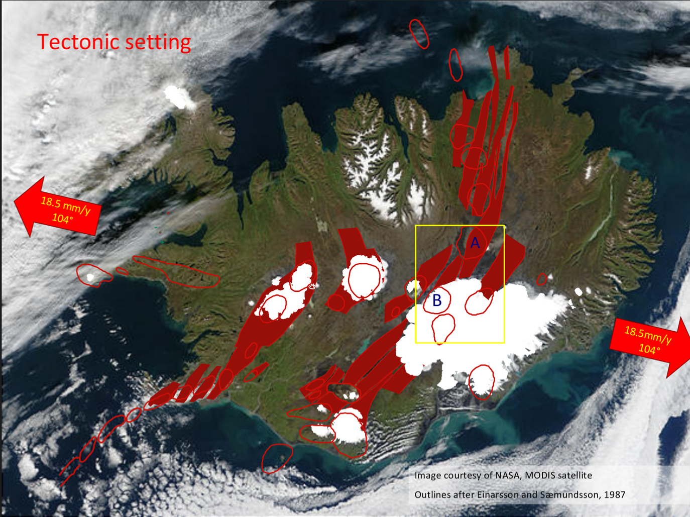
Iceland lies on a divergent plate boundary where two of the solid sections that make up the Earth’s crust (tectonic plates) are moving apart. This allows the solid material beneath the crust to rise upwards, and reduces the amount of pressure on it, allowing it to melt and form magma. Thus new material is formed and moves outwards in a process known as rifting a sea floor spreading. This is why there are volcanoes all the way along the centre of the North Atlantic Ocean, where the Eurasian and N. American tectonic plates are pulling apart. So why then, is Iceland more volcanically active than the rest of the plate boundary?
It is thought that Iceland is also underlain by a hot upwelling rising from the core of the Earth upwards, which is part of a convecting system within the solid Earth. This means that under Iceland it is also hotter than in other parts of the world. This also causes the solid Earth to melt and form magma.
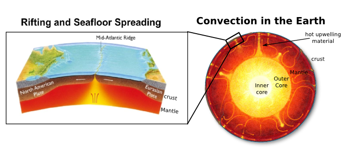
The combination of a plate boundary releasing pressure and an underlying hot upwelling, mean that Iceland has large amounts of magma generated and thus large numbers of volcanoes (30 active volcanic systems).
How do you locate earthquakes?
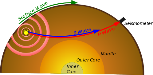
When an earthquake happens energy travels outwards as waves in all directions, like a ripple spreading across the surface of a pond. There are two main types of earthquake (seismic) waves: P waves which have a squashing together (longitudinal) motion and are faster, and S waves which have a side to side (transverse) motion and are slower. As the wave moves outwards when they pass a seismometer the ground will shake a bit and the seismometer will record the ground motion. Since the P wave is faster, the seismometer will first detect a little wobble of the ground when the P waves goes past and a bit later another wobble of the ground when the S wave goes past
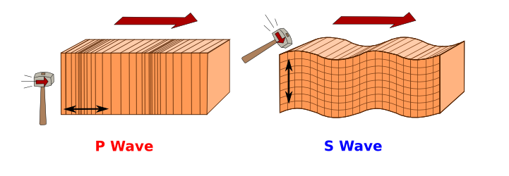

It is possible to work out how long the wave has been travelling for, and thus how far away the earthquake occurred, by looking at how long it takes the two waves to arrive at the station. By doing this at lots of different seismometers in different locations we can work backwards to find out the earthquake source location. The animation below shows this concept in action.
Why did the 2014 Bárðarbunga eruption not ground any flights like the 2010 Eyjafjallajökull eruption which closed European airspace during the Easter holidays?
In 2010 the eruption at Eyjafjallajökull occurred underneath a glacier, which caused a highly explosive eruption. When the hot magma (molten rock at more than 1000 °C) hits ice the magma cools and contracts extremely quickly. This turns the liquid magma into solid rock. The ice is heated so quickly that it turns to steam. This change from ice to steam results in a rapid expansion of the steam (an explosion), which breaks the contracting magma up into tiny fragments of chilled volcanic rock, known as ash. The huge power in this steam explosion, and the pressure of all the rising magma underground, blows the mixture of ash, volcanic gases and steam high into the air. The column of volcanic ash sent high into the sky by this explosive type of eruption is know as an ash plume. The eruption in 2010 from Eyjafjallajökull produced an ash plume 10 km high. The fine ash was then carried 1000’s of km by the wind towards Europe where it grounded over 100,000 flights.
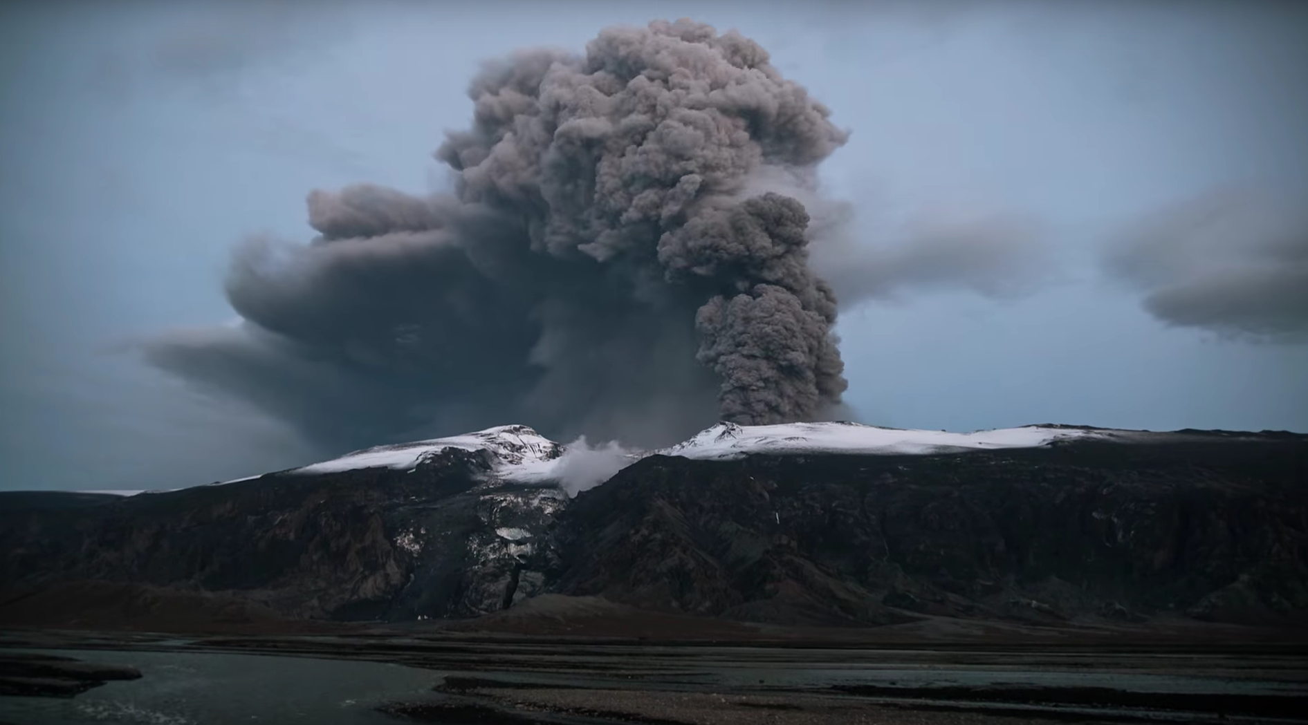
At Bárðarbunga in 2014 the magma flowed in an underground channel so far away from the volcano, that when it erupted there was no ice at the surface. The eruption was, therefore, gentle and the molten rock simply flowed out of the ground as lava. No ash was sent into the atmosphere, only steam and sulphur dioxide. The fountains of fire are from the molten rock being thrown 150 metres into the air by the expansion of volcanic gases that were already within the magma, and were released as it rose to the surface. The amount of magma erupted was much greater than in 2010, but there was far less impact on air travel because no ash plume was produced.
How does ash affect planes?
If volcanic ash gets into the engine of a plane it can cause serious deterioration of engine performance due to erosion of moving parts and/or partial or complete blocking of fuel nozzles. Particles of volcanic glass, which make up a component of volcanic ash, often have melting points below engine internal temperature. In-flight, particles will immediately melt if they go through an engine. Going through the turbine, the melted materials are rapidly cooled down and stick on the turbine vanes, and disturb the flow of high-pressure combustion gases. This disorder of the flow may stall the engine, in the worst cases. Ash can also confuse a plane’s airspeed sensors, block the pilots’ view out the windshield, and contaminate cabin air. Less immediate effects include erosion of external components, contamination of ventilation and pressurisation systems, and reduced cooling of electronic systems.
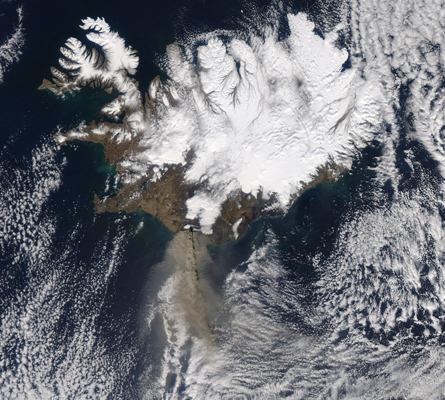
The 2010 Eyjafjallajökull eruption forced the closure of European airspace grounding 100,000 flights because of the worries that ash would damage the plane engines. Images below show the ash cloud being blown away from Iceland across the Atlantic.
Why are some volcanic eruptions very explosive while some are not?
Many things determine whether an eruption will be explosive or not. The most important ones are: if there is ice interaction, and how runny or thick the lava is (how viscous it is). The viscosity (how runny a magma is) is a major factor in controlling whether or not an eruption will be explosive. This is because viscous magma can trap gases which are in the magma, causing a build-up of pressure until the volcano can no longer contain it and a violent explosion releases the built up pressure, whereas fluid magma allows gases to escape easily.

Why do you sometimes get lightning during volcanic eruptions?
Lightning flashes sometimes occur above erupting volcanoes. During normal thunderstorms, ice crystals within the clouds collide generating an imbalance of electric charges that trigger lightning. In volcanic eruptions there are two possible sources for generating lightning. One source is the stationary electric charge caused by ash particles rubbing together in dense clouds near the ground. The other source of lightning happens near the stratosphere, nearly 12 miles (20 km) above the Earth's surface. When a volcanic ash cloud rises this high, the water vapour carried in it starts to freeze and form ice crystals which can rub against each other to build up charge and produce lightning, like in a normal thunder storm.
Are volcanic earthquakes anything like the earthquakes caused by fracking (hydraulic fracture stimulation)?
Earthquakes caused by fracking are similar in some ways to the kinds of earthquakes we study in the Cambridge Volcano Seismology Group, in that we consider injecting a fluid (magma/hydraulic fracturing fluid), into rock and breaking/cracking/ moving it, which can lead to tiny earthquakes.
Similarities to volcanic earthquakes:
-
Both the volcanic earthquakes and fracking induced earthquakes are, mostly, very tiny (less than magnitude 0), and are too small to be felt by humans, but there are lots of them.
-
Fracking sites track the clouds of tiny seismic events to get an understanding of where the rock is fracturing and how large the fractures are, to determine how much of the reservoir is fractured and how much they want further fracture it to make it easier for for gas to escape. This is the only way they know what the fractures look like underground. This is very similar to the way we track the tiny magma induced earthquakes to tell us where magma is travelling underground in volcanic systems.
It has been suggested that fracking could cause larger magnitude earthquakes if fracturing fluid lubricates big pre-existing weaknesses which are already under stress (see section below for more details). In volcanic systems though magma is not lubricating fault planes and allowing them to move, there is the suggestion that intruded magma changes the pressure on pre-existing faults nearby, either un-clamping them and allowing them to slip or clamping them more firmly shut and reducing the likelihood of earthquakes happening. If you want to know more about this, check out the scientific paper written by the Volcano Seismology Group: Triggered earthquakes suppressed by an evolving stress shadow from a propagating dyke.
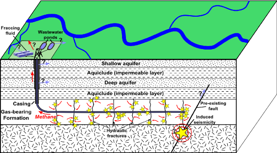
Hydraulic fracturing earthquakes—background
Hydraulic fracturing or 'fracking' is the process of pumping highly pressured fluid underground to fracture deep impermeable shale layers allowing the escape of natural gas.
Fracking can cause 'induced seismicity', which in this context is understood to mean microseismicity which results from human activity. A number of human activities can cause induced seismicity including mining, construction of large water reservoirs, waste water disposal by injection and fracking.
Fracking related earthquakes are generally < magnitude 0, well below the threshold which would be felt by humans (magnitude 3.0). Fracking is known to cause large amounts of microseismic activity with potentially much more which is too weak to be recorded by seismic instruments on the surface. In some areas (such as the Bowland site in Lancashire,) there are approaches used to try and minimise the amounts of induced seismicity, such as restricting the volumes of fluid ejection, careful monitoring of low level seismicity and detailed geological assessment of areas before fracking takes place.
However, there have been tentative links to larger magnitude earthquakes which some claim may have been caused by fluid injection, including a magnitude 5.7 in Oklahoma USA. Often pre-existing major faults which are already under large stress within the Earth’s crust, are generally clamped shut by the pressure of overlying rock. If fluid were to get into the fault surface, it could reduce the pressure on the fault allowing it to slip (like a puck on an air hockey table, which when tilted doesn’t move, until you turn on the flow of air, and then can easily slip). However making direct links to what sets off a primed fault which is likely to slip at some point, is very difficult, so it is hard to say definitively if such events can truly be linked to human fluid injection or not. This highlights the importance of a good geological understanding of an area and its pre-existing faults before fracking operations are given the go-ahead.
To the operators of the fracking site, induced seismicity is a useful way of tracking the fractures created, giving them some idea of the size and distribution, and how much of the reservoir has been fractured.
Hydraulic fracturing UK earthquakes—background
The earthquakes in Blackpool which have been linked to fracking were magnitude 2.3 followed by a magnitude 1.5. Magnitude 2.3 may just about be noticeable to humans, but barely, and the UK is thought to get an average of 15 magnitude 2.3 events every year. It is thought that these were caused by lubrication of pre-existing small scale faults 100 m x 100 m, which moved approximately 1 cm. An independent research report on the Blackpool site concluded that the maximum possible Mw achievable in that specific area could be up to magnitude 3.0 (magnitude 3.0 is equivalent to the vibrations caused by a large lorry passing nearby, so this is still a very small event). It is thought that the maximum magnitude seismic events likely to be caused by fracking in the UK are still likely to be smaller magnitude than naturally occurring British earthquakes and those induced by coal mining.
The conclusion on the UK research report from the Royal Society of Engineering and the Royal Society, concluded that the health, safety and environmental risks of fracking can be managed effectively in the UK, by implementing and enforcing best operational practice. However, they made several recommendations including calling for more research on the carbon footprint of shale gas extraction.
If you would like to learn more about fracking earthquakes and fracking in general we would recommend the websites listed below. It’s important to be careful when looking for further information online because many articles/websites make inaccurate claims, both in terms of minimising the risks or exaggerating them. The websites shown are selected for their science based nature and should contain impartial unbiased information:
- Shale-gas information-platform (SHIP) GFZ Potsdam (independent research institute)
- Geomechanical Study of Bowland Shale Seismicity (independent report on Blackpool fracking related earthquakes) – Nov 2011
- Review of Hydro-fracking risk and management conducted by the Royal Society and the Royal Academy of Engineering – 2012
- Research briefing paper on hydraulic fracturing for the House of parliament – 2015
Why do volcanoes and earthquakes both occur in the same places – at plate tectonic boundaries?
The outer-most layer of the Earth, the thin brittle crust varies from around 5-35km thickness, representing < 1% of the total thickness of the Earth. However, the crust is not a complete solid outer shell - it is cracked and split into many separate pieces which all fit together like a jigsaw puzzle. We call these interlocking pieces tectonic plates. Tectonic plates are not stationary but are always moving around, changing position on the Earth’s surface very slowly (several mm per yr). This means that the places where tectonic plates meet (plate boundaries, where they crash into each other, are forced down beneath each other, pull apart or slide past each other), are very active and dynamic regions of the earth. It is here at plate tectonic boundaries that the majority of earthquakes and volcanoes are located.
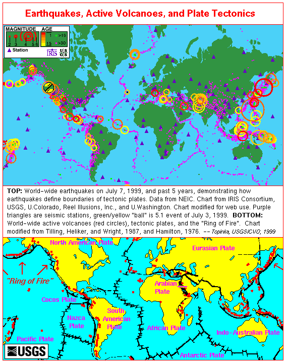
Volcanoes occur at plate tectonic boundaries because they provide special conditions which allows the normally solid mantle (the layer of the earth beneath the crust) to melt (see section – where does magma come from? for details).
The majority of earthquakes occur at plate tectonic boundaries because moving large chunks of rock past each other is very difficult, and there is a lot of friction. Often the two tectonic plates moving past each other get stuck, becoming locked together and can’t move. But the remainder of the plates continue moving, causing more and more pressure to build up on the stuck locked section. Eventually the locked section can’t support the amount of pressure and the plates suddenly slip past each other very quickly – this is what causes tectonic earthquakes. Since there are lots of volcanoes at plate boundaries, there are also earthquakes related to the movement of magma in volcanoes, such as the ones we talk about in our exhibit Explosive Earth. But volcanic earthquakes are usually very very small, releasing tiny amounts of energy compared to big tectonic earthquakes.
Where does magma come from?
The majority of the Earth is solid rock. There is no layer of magma lying underneath our feet. The outer layer, the crust, is cold brittle rock; the next layer, the mantle, is very hot, squishy rock but it is still solid. It isn’t until we reach the core, over half way to the centre of the earth, that there is any liquid, and the core is actually made of molten metal, not molten rock, with a tiny solid bit of metal right in the centre – the inner core.
But if the majority of the Earth is solid rock, then where does magma come from, and how is it formed? Though the majority of the mantle is solid, in certain special conditions it can melt to form magma. The melting point of rock is dependent on both the pressure and temperature. Under normal conditions inside the Earth, the mantle is below the melting point, but there are three main scenarios which allow the solid mantle to melt:
-
Reducing the pressure
By taking the solid rock of the mantle to shallower depths in the Earth, the confining pressure is reduced and allows decompression melting to occur. This happens at plate tectonic boundaries where 2 plates are moving apart and the gap forming between them allows solid mantle material to rise up, and melt as the pressure is reduced. This is why there are many underwater volcanoes all the way down the middle of the North Atlantic Ocean, where the North American and Eurasian tectonic plates are moving apart.
-
Increasing the temperature
In some scenarios, the temperature at depth is hotter than normal, and this can cause melting of the mantle. It is thought this happens when mantle plumes of hot material rise from the core mantle boundary, as part of a convecting system in the mantle. One example of what scientists believe is melting caused by a mantle plume is Hawaii.
-
Adding volatiles (e.g., water)
Adding volatiles such as water to the mantle lowers the melting temperature, so even at normal temperatures the mantle can melt to form magma. Subduction zones where one of the Earth’s tectonic plates is forced down under another, are regions where volatiles are added to the mantle. The down-going plate releases water it has brought down with it, and from mineral reactions taking place within it. This water hydrates the mantle above, reducing the melting point and allowing magma to form. This is why there are volcanoes along subduction zones, such as along Chilean coast, where the Nazca plate is being subducted beneath the South American plate.

How are volcanic earthquakes different from tectonic earthquakes?
Tectonic earthquakes occur due to the Earth’s tectonic plates sliding past each other which causes locking, pressure build up and sudden release creating large earthquakes at these boundaries. This is a completely different mechanism to the kind of earthquakes we at the Cambridge Volcano Seismology Group, look a,t which concern fluid injection of magma, either fracturing the crust it moves into or facilitating movement on pre-existing fractures/weaknesses.
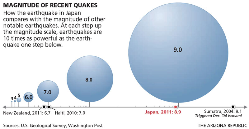
In general tectonic earthquakes are on a much larger scale than anything we look at. In simple terms this can be explained by the fact that earthquake size relates to the amount of fault surface that has slipped. Tectonic events, where large 100s km squared sections of tectonic plates move, are many many times larger than the movement of small fault planes likely to be caused by magma intrusion. Accordingly, subduction zones have up to Mw 9.5 events compared to the maximum magnitude of 3.0 that we observe in magma propagation events.
Why don’t we get many earthquakes in the UK/will we get some?
We don’t get many large earthquakes in the UK because we are not near a plate tectonic boundary, where the majority of earthquakes occur. There are also no active volcanoes so we also do not get any of the earthquakes related to magma movement, like the ones we talk about in the Explosive Earth exhibit.
But we do get earthquakes in the UK—a few happen every few days, they are just very small (generally < magnitude 2), which means that usually they are just too small for people to feel. The largest earthquake ever to happen in the UK was a 6.1Mw off the east coast of England in the North Sea. The most damaging earthquake in the UK in recent history was in 1884 near Colchester. Because it was so long ago we don’t know exactly how big it was (probably around 4.5Mw), but historical records show some 1200 buildings required repairs, and 3 to 5 people were killed.
We don’t know exactly why we get these small earthquakes in the UK, but it is thought that most may be due to the land readjusting after the massive weight of glaciers was removed after the last ice age 1000s of years ago, allowing the land to uplift .
For more information, check out the British Geological Survey (BGS)
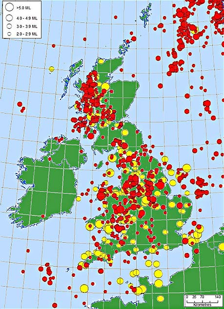
Image from British Geological Survey (BGS) showing earthquakes that have been reported in historical records (yellow) from 1832 to 1970 for earthquakes of magnitude above 3.0 and earthquakes that have been measured on modern instruments (red) from 1970 to present for earthquakes with magnitude > 2.0.
How many volcanoes/volcanic eruptions are there in the world?
About 1,500 different volcanoes have erupted over the past 10,000 years, but only about 60 erupt each year. On any given day, there are about 20 volcanoes erupting somewhere in the world.
This is actually a very difficult question to answer. We don’t know exactly how many volcanoes there are, because sometimes we don’t know if they are extinct (will never erupt again) or not, and some are under the sea and hard to detect. It also depends on what we count as a single volcano-is one volcanic vent an individual volcano or do we count an entire volcanic field which has many vents which are all connected to the same magma chamber, as a single volcano? Have a look at how many volcanoes a erupting right now.
How many earthquakes are there in the world?
The USGS estimates that several million earthquakes occur in the world each year. Many go undetected because they hit remote areas or have very small magnitudes. The NEIC (National Earthquake Information Centre) now locates about 50 reasonably large earthquakes each day (>4.5Mw only located), or about 20,000 a year.
What happens when magma and ice interact in an eruption?
When ice comes into contact with magma it causes very explosive, ash-heavy eruptions. The very hot magma is instantly cooled and solidifies, turning into rock. The ice is rapidly heated beyond its boiling point and turns into steam. When ice turns to steam, it expands rapidly, fragmenting the solidified rock and shattering it into many tiny particles of ash.
What are the gases that are dissolved in magma?
A whole range of different gases can be found dissolved in magma at depth, but the most common are water vapour (> 60% total gases), carbon dioxide (10–40% total gases) and sulphur as sulphur dioxide or hydrogen sulphide.
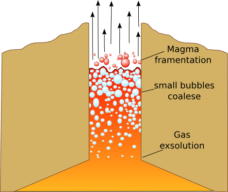
Whether or not a gas stays dissolved in the magma or comes out of solution, depends on what the gas is, as well as the pressure, temperature and composition of the magma itself. Generally as magma rises to the surface, surrounding pressure on it decreases, and gas is able to come out of solution, or exsolve from the magma.
Initially, exsolved gas bubbles are very small, and find it difficult to rise up through the magma, even though they are less dense, because the buoyancy force of the bubble is outweighed by the viscous forces of the magma holding it back. But as magma moves upwards gas bubbles expand as the pressure is further reduced, and many bubbles start to coalesce together forming larger collections of gas, making a foam with the magma. Eventually the amount of gas in the foam is much greater than the amount of magma, causing it to fragment into tiny pieces which are brought up with the rising gases.
What is a volcanic plug?
A volcanic plug or volcanic neck forms when lava solidifies inside the volcanic vent, blocking the rise of further magma to the surface, like when glue dries in the nozzle of a tube of glue. If the volcano is still active, volcanic plugs can cause very explosive eruptions, as gas can build up beneath the plug increasing the pressure inside the volcano. In some cases long after a volcano is extinct, the hard volcanic plug material can be preserved after the rest of the volcano has been eroded away, leaving distinctive upright approximately cylindrical landforms. Devils tower in Wyoming, USA, is one of the most famous volcanic plugs.

What makes magma runny or viscous?
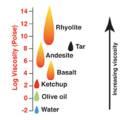
The viscosity (thickness) of magma is a major factor in controlling whether an eruption will be explosive or not. This is because viscous magma can trap exsolving gases causing a build up of pressure, whereas fluid magma allows gases to escape easily.
The magma composition is a controlling factor which determines magma viscosity, in particular its silica content. Magma with a high silica content will be very viscous whereas magma with a low silica content will be very fluid. Silica-oxygen molecular bonds are very strong and can form long chains, which give the fluid viscous strength.
If you melt the Earth’s solid mantle at depth, you form a basic low silica content magma. There are two main processes which increase the silica content of a magma:
-
Crustal Assimilation
The continental parts of the Earth’s crust are predominantly made up of high silica content rocks. As magma moves up through the crust it can melt bits of the surrounding rock and assimilate them, becoming more silica rich.
-
Magma ponding and evolution
If the magma stalls at depth and doesn’t reach the surface it starts to cool very slowly within the crust. Certain iron rich (mafic) minerals within the magma can crystallize at high temperatures, so these minerals crystallize out first and then sink to the bottom. Over long periods of time, by slowly crystallizing the iron rich minerals out, the remaining fluid magma becomes relatively enriched in silica. This is known as magma evolution.
Whether or not either of these silica enrichment processes happens or if the magma stays at it’s original low-silica composition, depends to a large degree on the tectonic setting of where the magma forms (see Why do volcanoes and earthquakes both occur in the same places – at plate tectonic boundaries? to learn about why magma forms at tectonic plate boundaries).
In divergent plate boundaries, where two tectonic plates are moving apart, magma doesn’t have thick crust to travel through to get to the surface, and the path upwards is very easy so it doesn’t tend to pond and evolve. So at divergent plate boundaries (like in Iceland, the setting for the Explosive Earth exhibit) magma tends to be very basic, with a low silica content and thus effusive splattery eruptions. On the other hand at convergent plate boundaries where two tectonic plates are moving together and one is forced under the other, magma which is formed has to move through a thick layer of continental crust, where it can assimilate crustal rocks and is likely to pond and evolve. Thus convergent plate margins tend to have higher silica content magma and more explosive eruptions.
This diagram shows how viscous different common fluids are. It's taken from this website, which has lots more interesting information on magma viscosity and other magma properties, if you want to know more
How is ash formed?
When gases are released from magma as it rises, the gas bubbles join to together and coalesce, forming a magma foam. This foam is a lot less dense than normal magma and so it accelerates quickly up the conduit out of the volcano. Once the gas makes up the majority of the foam (70-80%), it fragments the magma, tearing it apart into tiny pieces which continue to rise up with the moving hot gases into the atmosphere, where they cool into tiny rock ash particles.
Lots of ash is produced when magma and water come into contact, in what is known as a phreatomagmatic eruption. This is what Icelandic authorities were worried about during the 2014 Bardarbunga eruption in Iceland, since the volcano was under a glacier. When water comes into contact with magma it is rapidly heated beyond its boiling point and turns into steam. When this happens, it expands rapidly, quickly fragmenting the lava, which is also cooled by the water, forming tiny ash particles.

What types of igneous intrusions are?
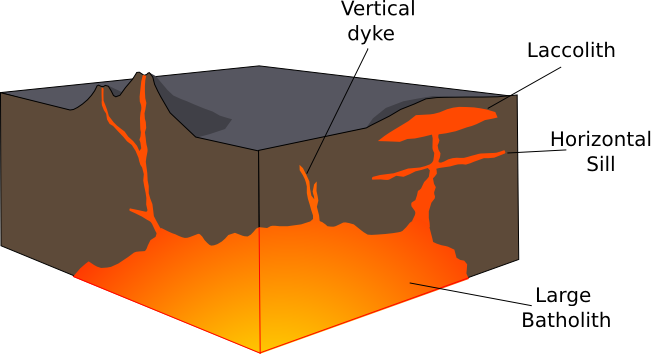
If magma does not reach the surface it can cool inside the Earth’s crust creating an igneous intrusion. There are several types of igneous intrusion. Sometimes magma moves upwards as a vertical sheet, cooling to form a vertical intrusion known as a dyke. Sometimes magma moves as a horizontal sheet, cooling to form a horizontal igneous sill. In some cases a horizontal sill can become inflated forming a blister like intrusion with a convex upper surface known as a laccolith. Sometimes whole large magma chambers just sit in the crust and cool down with no magma reaching the surface. These large deep intrusions are known as batholiths (or sometimes plutons).
How do you make tall buildings earthquake-proof?
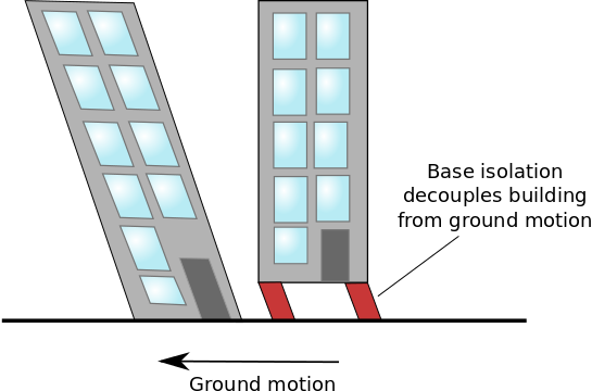
Tall buildings feel the effects of earthquakes much more so than short buildings since the vibrations are amplified over their height. So engineers have come up with many clever tricks to try and protect skyscrapers from earthquakes. Base isolation can be used, so buildings do not sit directly on the ground, and thus are decoupled from ground movement. Instead buildings sit on top of systems of ball bearings or springs which act as shock absorbers. Other systems attempt to balance out the swaying at the base of tall buildings by putting in a free swinging mass at the top, like a giant pendulum. Check out the video below to see base isolation in action and try this website if you want to find out more
What types of earthquake waves are there?
The main type of earthquake waves are P and S waves, which travel down through the inside of the earth, and surface waves which travel through the crust. Have a look at the video below to see what they look like. We only discuss one type of surface wave, known as Rayleigh waves, which have a retrograde elliptical motion (as shown in the figure). But there are also another type of surface waves called Love waves which has a horizontal motion.

Though there are only a couple of types of waves that travel within the earth (P and S waves), they can bounce and be reflected off many different surfaces, like the core mantle boundary or the Earth’s surface, as well as changing from one type to another, eg: a P wave can be changed into an S wave and vice versa. For each of these different paths through the earth we give the waves a different name. For example PcP is a P wave that bounces off the core mantle boundary before being recorded at the surface, a PKiKP is a P wave which travels through the mantle and outer core before bouncing off the inner core and an SS phase is an S wave which bounces off the surface. There are hundreds of different seismic wave 'phases' such as these that can be seen in earthquake records, which can tell us about the deep structure inside the earth. That’s how we know things like the outer core is liquid and how big it is. Unfortunately lots of them are very small, arriving at similar times, and interfering with each other, so scientists use lots of clever signal processing techniques to find and look at the specific phases they are interested in.
